Monday, February 6, 2012

Lake Shasta ~ Kennett, CA

Though the old mining town of Kennett was a faded relic of its boomtown self by the time it was flooded by Lake Shasta in 1944, it was still home to a hundred people. Like other “gold rush” towns in northern California, it was established for mining and prospecting in the 1850s, though it wasn’t until a railroad camp was built in 1883, with over a thousand Chinese laborers, that the population began to rise substantially.
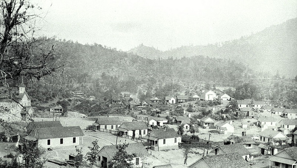
One building that wasn't moved was the Kennett Elementary School --
 larger wooden building on the left of this photo.
Kennett was established in 1884 as a railroad town beside the Sacramento River when the California & Oregon Railroad extended its tracks from Redding to Delta. The place was first used as an emergency brake-testing station and was named by the railroad for Squire Kennett, a railroad stockholder and financier.

Goldminer Charles Butters arrived approximately 1885 and began purchasing land. The Kennett Post Office was established in 1886 (and discontinued in 1942). By 1905 Butters owned over 6,000 acres and began building up the town, complete with roads, churches, schools and even an opera house. Kennett was home to the famous Diamond Bar Saloon; offices of the Justice of the Peace were located in the saloon building basement. The town suffered a devastating fire in 1904.

In 1905 electricity arrived and the town soon became a copper mining boom. In 1907 the Mammoth Copper Company built a copper smelter. It generated thick fumes that sometimes enveloped the whole town in a haze of bluish smoke ... the hills around the town were exfoliated and denuded by its acid fumes. Farmers in the valley 15 miles away began a suit against the company for destruction of their crops and the smelter was shut down by court order in 1919. It operated again briefly in 1924 and was dismantled in 1925.

By 1910, Kennett boasted a population of over 10,000 and was the 2nd largest town in Shasta County and the most prosperous mining town in the west. But the mines closed after the end of WWI, the smelter soon followed, and Kennett’s population fell over the next two decades.

The remains of Kennett – along with many of the region’s smelters, paint factories, mines and their despoiled soils – lie  beneath 400’ of water in the deepest part of Shasta Lake just north of the dam. Many of the wooden buildings were either dismantled or moved entirely out of Kennett just prior to the rising waters. But many still remain at the bottom of Shasta Lake. One that wasn't moved was the Kennett Elementary School.

Other towns inundated by Lake Shasta were Heroult, Baird & Copper City.

Lake Sakakawea & Garrison Dam ~ Elbowoods, ND


According to the Fort Laramie Treaty of 1851, the territorial lands of the Three Tribes was an area of more than 12 million acres, extending from east of the Missouri River into Montana. In the following years, to justify taking more land, the federal government, through several allotment acts and the 1910 Homestead Act, reduced the reservation further to less than three million acres. The flooding of the prime river bottomland was yet another assault on the autonomy of the cultures of the Mandan, Hidatsa and Arikara/Sahnish. Flooding the reservation bottomlands reduced the reservation even further, leaving only 500,000 acres of individual and tribally owned lands.
Map shows communities existing on the
Fort Berthold Reservation before dam construction.
Beginning in the 1940s, the Corps of Engineers built five main-stem projects that destroyed over 550 square miles of tribal land in North and South Dakota and dislocated more than 900 Indian families. The most devastating effects suffered by a single reservation were experienced by the Three Affiliated Tribes whose lifeways were almost totally destroyed by the Garrison Dam, as a part of the Pick-Sloan Project.

The construction of Garrison Dam on tribal land resulted in the taking of 152,360 acres. Over 25 percent of the reservation’s total land base was deluged by the dam’s reservoir (known as Lake Sakakawea today). The remainder of the Mandan, Hidatsa, and Arikara/Sahnish lands was segmented into five water-bound sections. The project required the relocation of 325 families, or approximately 80 percent of the tribal membership. For many successful years as ranchers and farmers, these industrious people lost 94 percent of their agricultural lands.

The Corps of Engineers, without authorization from Congress, altered the project’s specifications in order to protect Williston, North Dakota, and to prevent interference with the Bureau of Reclamation irrigation projects. However, nothing was done to safeguard Mandan, Hidatsa or Arikara/Sahnish communities. When the army threatened to confiscate the land it needed by right of eminent domain, the Three Affiliated Tribes protested in Washington, succeeding in having Congress halt all expenditures for the Garrison Dam project until they received a suitable settlement. This legal action was based on the Fort Laramie Treaty of 1851, which provided that land could not be taken from the tribes without their consent and that of Congress.

The lands that the Three Affiliated Tribes were forced to give up were not just some undesirable tracts assigned them by a government more concerned with encouraging the westward movement of the American pioneer than with the fate of the native inhabitants. The river valley environment of the Three Tribes had been their home for perhaps more than a millennium, although not the particular segment of the valley that lay above the Garrison Dam. They had developed ways of adjusting to this environment over a time span nearly inconceivable to white Americans. Moreover, they had emotional and religious ties with it that no American descending from old world immigrants would fully comprehend.

The original communities before the flooding of the Garrison Dam were Elbowoods, including the central business community which housed the Indian Bureau, the Indian school and the hospital. The communities of Red Butte, Lucky Mound, Nishu, Beaver Creek, Independence, Shell Creek and Charging Eagle were also flooded. The Mandans had settled in the Red Butte and Charging Eagle area, and the Sahnish settled in the Nishu and Beaver Creek area. Independence was settled by the Mandan and Hidatsa, and Lucky Mound and Shell Creek by the Hidatsa. Elbowoods was a combination of all Three Tribes. The other communities had government, Indian day and boarding schools, churches, communal playgrounds, parks, and cemeteries. Some had ferries. Although parts of these communities remain, gone were the close traditional gatherings and community living; as were natural resources, such as desirable land for agriculture, timber that provided logs for homes, fence posts and shelter for stock, coal and oil deposits, natural food sources and wildlife habitats for which most would or could never be compensated.
Map shows Lake Sakakawea and the inundated
communities after dam construction.
The reservoir that formed behind the Army Corps of Engineers’ Garrison Dam was named after Sacajawea, the legendary Shoshone Indian woman who guided Lewis and Clark through the mountains of Montana. 178-mile-long Lake Sakakawea, the third largest reservoir in the country, flooded a quarter of the Fort Berthold Indian Reservation, forcing the relocation of 325 families from the towns of Sanish, Elbowoods, Lucky Mound, Shell Creek, Nishu, Charging Eagle, Beaver Creek, Red Butte, Independence and Van Hook.

Sunday, February 5, 2012

Wild River (1960) - Tennessee Valley

Filmed on location in the Tennessee Valley, Wild River is set in the early 1930s. Montgomery Clift plays an idealistic TVA agent, assigned to convince the locals to move from their property so that a beneficial dam can be built. The principal holdout is feisty octogenarian Jo Van Fleet, who refuses to budge from her land, convinced that she will die if she ever gives an inch. Her prophecy turns out to be true, as Van Fleet becomes yet another sacrifice to progress. Clift also runs into opposition because of his fair treatment of the local black population. Lee Remick costars as Van Fleet's granddaughter, who comes to love and understand the sensitive Clift. Watch for an uncredited Bruce Dern in his film debut. 

Some dated fuzzy-headed liberalism aside, Wild River is a masterful recreation of a difficult, complex period in American history. In 2002 it was selected for preservation in the United States National Film Registry by the Library of Congress as being culturally, historically or aesthetically significant.

Wild River


Thursday, February 2, 2012

Watauga Dam & Reservoir ~ Butler, TN

Butler was the largest single community, and the only incorporated town, removed by the Tennessee Valley Authority (TVA) throughout that entire massive, depression-era public works project to modernize and electrify the rural parts of the southeastern United States. It was originally located in eastern Tennessee, where the Roan Creek and Watauga River meet in Johnson County, and was the commercial center for the Watauga Valley ... it was the only real town in the region, with over 600 residents and more than 125 homes and businesses.

A typical southern town, it had two barbershops, two beauty parlors, markets, the Blue Bird Cafe, hardware store, drug store, a few service stations, a few hotels, three churches, a rail station, Masonic lodge, a brick City Hall, bank and doctors and dentists offices. Located in the forested hills of Appalachia, local industries were mostly wood related, and included a lumber company, a crating company, a furniture company and a casket company.


But the town also had a flooding problem, as did many others located along rivers in Tennessee in the days before the TVA. According to one Butler history, the town experienced flooding in 1867, 1886, 1901, 1902, 1916, 1924 and 1940.

In 1948, before the reservoir was filled, the town was relocated to higher ground on Tennessee State Route 67. The relocation project required construction of 54.9 miles (88.4 km) of roads and highways, three bridges, and 66 miles (106 km) of utility lines, as well as the relocation of of 1,281 graves. Some families opted to leave the graves of their ancestors undisturbed, so they are still at the old site, along with a reported slave graveyard that TVA crews never found.

The original town is now known at Old Butler ... "the town that wouldn't drown". In a 1983 drawdown to service the dam, former residents were allowed to visit the exposed site for a brief glimpse of their old town: Don Stout’s shoe store (made of stone) and the one room jail house (made of concrete) stood out from the other foundations and building pads along muddy streets that were still lined with trees ... long dead but preserved by the water. 

A brief glimpse.

TVA Cemetery-Relocation Program

Subject: WATAUGA LAKE CEMETERIES
15 Dec 1998

 
Dear Ms. Katzman:
 
Thank you for your interest in the Tennessee Valley Authority (TVA). In the Watauga Reservoir area the policies, procedures, and methods followed in carrying out the cemetery-relocation program were in general the same as those employed for similar work in previously completed TVA reservoirs. Removals and reinterments were governed by the rules and regulations of the Tennessee Dept. of Health and the North Carolina State Board of Health.
 
Reconnaissance surveys made in order to locate cemeteries in the Watauga Reservoir area had been completed when the grave-removal program was begun in the spring of 1942. As detail surveys of the affected cemeteries were being made, relatives of the interred persons were being interviewed to ascertain their wishes in regard to disposition of the graves. Work on the Watauga project was discontinued in compliance with an order issued by the War Production Board November 21, 1942 but at that time all cemeteries known to be affected had been mapped and approximately one-half of the relatives of the deceased had been contacted.
 
Grave-relocation activities were not resumed until the spring of 1947, and it was considered advisable, at that time, to re-contact practically all the persons with whom arrangements had been made in 1942 for the removal of graves of relatives. Actual removal operations were started in May 1947, but bad weather and the inability of some of the surviving kin to decide on reinterment sites made it necessary to stop work during the winter of 1947-48. Activities were again resumed in the summer of 1948, and all but 20 of the affected graves were relocated at that time. A special crew removed these holdover graves in the fall of the same year.
 
Of the 103 cemeteries, 3452 graves were investigated, and 1281 graves were removed. Investigation of all cemeteries in the reservoir area revealed that 40 would be flooded or affected by wave action, 7 would be isolated, 1 would be affected by construction, 24 would be served by relocated roads, and 31 would not be flooded and would continue to have access after filling of the reservoir. A total of 874 monuments including both head-and foot-stones were removed, cleaned and reset.
 
Today TVA has a cemetery relocation database that lists the graves affected, the name of the original cemetery, and the name of the new cemetery. I have attached the cemetery relocation database information for Watauga.
 
This is the only information available in-house. All other information, such as the original cemetery maps and the relocation forms with the next of kin's signature, have been transferred to the National Archives--Southeast Region, 1557 St. Joseph Avenue, East Point, Georgia 30344, (404) 763-7650.
 
I trust this information will prove useful to your research.
 
Sincerely,

Patricia Bernard Ezzell
Historian


Wolf Creek Dam ~ Lake Cumberland, KY

Over 50 years ago, the Army Corp of Engineers built Wolf Creek Dam on the Cumberland River and began the creation of Lake Cumberland. Located in Clinton, Laurel, McCreary, Pulaski, Russell and Wayne counties in south-central Kentucky, Lake Cumberland shoreline measures 1,255 miles and is spread over 65,330 acres. The main lake is 101 miles long and over 1 mile across at its widest point.

Originally planned from the 1920s and enacted by Congress in the 1930s, with groundbreaking in 1941, early construction of Wolf Creek Dam to impound the Cumberland River was halted by World War II. Following the war, work resumed and the dam was closed in 1950, beginning what was originally named Wolf Creek Reservoir. The name “Wolf Creek” comes from the original planned location for the dam, several miles upstream near the confluence of Wolf Creek with the Cumberland River. Though the location changed, the name remained. The body of water was officially renamed “Lake Cumberland” in 1954.
 

Wolf Creek Dam is the 22nd largest dam in the United States. The primary reasons for the dam was for flood control of the occasionally wild Cumberland River, and for hydroelectric power generation.

Once the purchase price was agreed upon, properties were numbered with the owner's tract number. Owners received a "Notice of Acceptance of Option for Purchase of Land" letter with a full copy of the accepted options from the U.S. Army Corps of Engineers. Most people tried to remain on their properties as long as possible. Pictured is the numbered farm of Shell and Gladys Oatts, which was moved to Hwy. 1275 before the property was flooded. 

It wasn’t only farmland that was flooded—sometimes whole towns were lost to the lake. Communities such as Rowena, Horseshoe Bottom (currently under Jamestown Marina), Swan Pond Bottom, Lulu, Long Bottom, Indian Creek and Stokes would cease to exist once the lake filled. Residents in Long Bottom were the first to leave their homes, churches and schools. Shortly after, other communities were evacuated.

123 cemeteries and the remains of 2,800 people also were relocated because of the impoundment for Lake Cumberland. Headstones, coffin lids and remains were removed and reinterred in cemeteries on higher ground. With the lowering of Lake Cumberland in 2007, several small cemeteries resurfaced, exposing empty coffins and burial vaults. For more information, try to find a copy of Carol L. Sanders book, The Cemeteries Under Lake Cumberland and Russell County, Kentucky, Death Records, 1852-1858, 1874, 1878, 1903-04. 

Burnside was more fortunate. Before the dam was completed in the spring of 1951, entire structures in the town were moved to higher ground. Houses were built and businesses relocated. Many of the businesses refused to relocate to "Upper" Burnside. Jobs were lost and some residents, mostly the young, moved on to bigger towns and new jobs.

The following pictures show what the area of Burnside looked like during the flooding. A bridge span was submerged when the lake filled up faster than expected.

In the background you can see the tunnel & bridge of old Rt. 27.

The lake as it approaches the rooftops of abandoned buildings.

Burnside Supply Co. as it was being swallowed up.
In 2007, fearing a break in the dam, the lake was lowered to a level of 680 feet. Repairs to the dam were completed in 2013.

Thanks to Jim Patton for bringing this ghost lake to my attention!